A Championship Long event with 9 different courses for all age and difficulty levels. This is a Canada Cup level event sanctioned by Orienteering Canada.
Start List
Schedule
- Start Window: 09:00-10:30
- Time Limit: 3 hours
- Course Close: 14:00
Parking
There are 2 parking areas:
- Parking 1: Kelowna Nordic Summit parking lot at the Event Arena.
- Generally for those who need a less physical walk to the Event Arena.
- Parking 2: Bottom of Kallis FSR at intersection with Highway 33.
- Parking 2 to Event Arena: 900 m distance and 40 m climb.
- Generally for those who enjoy a more physical walk to the Event Arena.
Please carpool as much as possible to this event to ease the pressure on the relatively small parking areas.
Toilets
There are 3 port-a-potties at Parking 1 / Event Arena and 1 port-a-potty at Parking 2.
There is 1 outhouse at Parking 1 / Event Arena and 1 outhouse at Parking 2. Please use the port-a-potties at the Event Arena and not the outhouses.
Arena to Start
- Distance: 500 m
- Climb: 60 m
- There are no port-a-potties at the Start or on the route to it.
Special symbols and their definitions on this map.
| Course | Distance (km) | Climb (m) | Controls | Classes | Map Scale | Technical Difficulty |
|---|---|---|---|---|---|---|
| Course 1 | 1.9 | 30 | 9 | F10, M10, Open 1 | 1:7500 | Beginner (TD1) |
| Course 2 | 2.9 | 45 | 13 | F12, M12, Open 2 | 1:7500 | Novice (TD2) |
| Course 3 | 3.2 | 70 | 15 | F14, M14, F16S, M16S, Open 3 | 1:10000 | Intermediate (TD3) |
| Course 4 | 4.3 | 140 | 15 | F16, M16, Open 4 | 1:10000 | Intermediate (TD3) |
| Course 5 | 2.3 | 40 | 10 | F75, M75, F80, M80, F85, M85, F90, M90, Open 5 | 1:7500 | Veteran (TD4) |
| Course 6 | 4.5 | 110 | 15 | F18, F45, F55, F65, M65, F20S, M20S, F21S, Open 6 | 1:10000 | Expert (TD5) |
| Course 7 | 6.5 | 175 | 17 | M18, F20*, F35, M45, M55, M21S, Open 7 | 1:10000 *1:15000 | Elite (TD5) |
| Course 8 | 8.3 | 230 | 22 | M20, F21E, M35, Open 8 | 1:15000 | Elite (TD5) |
| Course 9 | 10.6 | 315 | 23 | M21E, Open 9 | 1:15000 | Elite (TD5) |
Organizing Team
- Course Planner: Brian May (Sage)
- Controller: Stan Woods (GVOC)
Map: Thunder Mountain
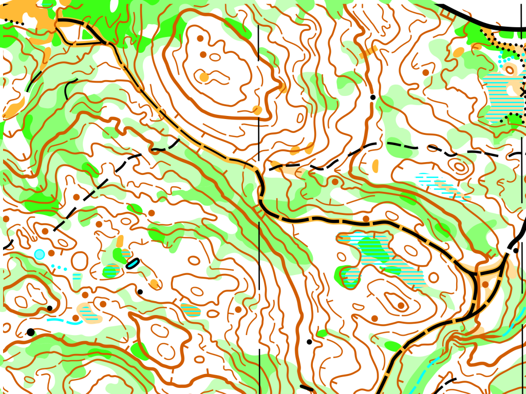
This map features hillier terrain with larger contour features and small pockets of contour detail. The vegetation is very similar to Kelowna Nordic Core, but there are sections of very dense forest in otherwise highly runnable, white forest with no deadfall. Combined with the low density trail network, these topographical and vegetation features drive challenging route choice decisions perfect for the ultimate long distance orienteering race.
- Mapper: Bryan Chubb
- Year Mapped: 2021-2022
- Standard: ISOM2017-2
- Print Scale: 1:10,000 for most categories, 1:15,000 for elite categories, and 1:7500 for other select categories, as per Orienteering Canada Canada Cup standards
- 2020 Computer Generated Map of Part of the Area: Available Here for Fairness Purposes